After competing at the Commonwealth Games in Australia, British Olympic swimmer Lizzie Simmonds and her boyfriend Tom hired a Wilderness motorhome to travel around New Zealand’s South Island.
|
Contents |
Day 1: Christchurch to the West Coast
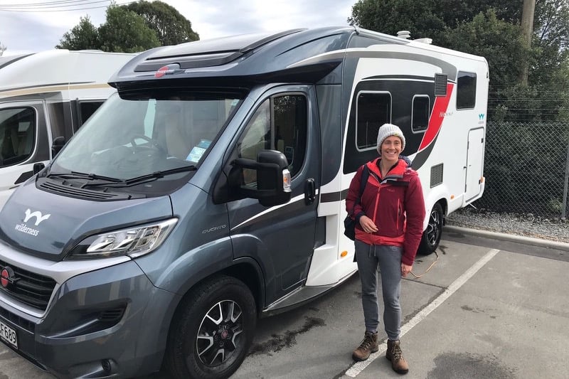
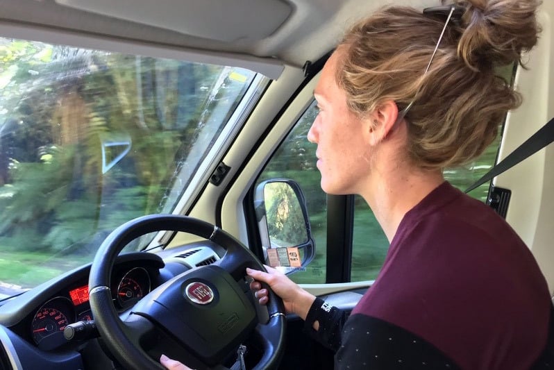
Picking up our motorhome at the Christchurch Wilderness depot marked the beginning of our South Island adventure. We’d chosen the Twin / King for 2 as it has ample storage space for bags (I’d come straight from competing on the Gold Coast), and also because Tom is 6ft 6in tall and this particular motorhome supports a permanent king-sized bed in the back! We were both a little unsure of what to expect but this really was one of the unusual cases where the photos and descriptions on the booking website didn’t actually do the vehicle justice. We were blown away by the high spec interior, clever space-saving storage zones, and fully functioning kitchen and bathroom. A quick tour from the Wilderness staff (plus a pre-installed instruction video in case we forgot something) and we were ready to hit the road.
With only ten days on the island we’d highlighted some ‘must see’ places but had left our itinerary relatively open. One of the advantages of being in a motorhome is that travel becomes super flexible – when you can sleep, eat, and wash in your vehicle, there’s no need to create rigid travel plans, meaning we could quickly adapt to spontaneous journey changes and unpredictable weather.
After leaving Christchurch we headed towards Arthur’s Pass, and watched the landscape turn from lush fields (very similar to most of the UK), into mountainous terrain (very unlike the UK!). The higher areas were snow covered and misty but, as we drove upwards into the clouds, the mist turned to rain and our views were marred a little. We’d planned to stop in Arthur’s Pass and do some walking, but the weather had shrouded the mountains in a veil of fog and so we powered on towards the West Coast. One of the things we were soon to learn about New Zealand is that the weather waits for nobody!
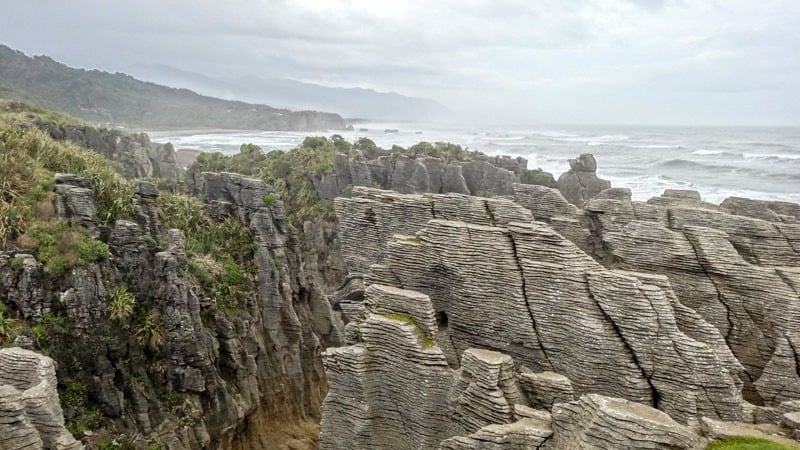
We arrived on the West Coast late in the afternoon and decided to drive north to stay in Punakaiki, where the famous ‘Pancake Rocks’ scatter the coastline. Darkness was falling as we approached, so we pulled up to a campsite that was so close to the beach that we could hear the waves crashing during the night. Having done a supermarket shop before leaving Christchurch, we whipped up a mushroom and pea risotto for dinner in the motorhome (Tom is an awesome cook), and settled in for the evening, ready for the adventure ahead.
Day 2: Punakaiki to Franz Josef Glacier
The weather had improved a little by the next morning and by daylight Tom and I could fully appreciate our surroundings. Only a hundred yards from the beach, we were actually in the middle of a dense jungle of woodland stretching across the nearby rocky outcrops and towards the horizon. Walking inland along the river down a narrow deserted path, we marvelled at the thick ferns and conifers that carpeted the valley. After an hour we found that the path had been closed due to recent bad weather. With no other way through we headed back to base and set off for the Pancake Rocks.
If you’re interested in geology, then New Zealand is a haven of fascinating rock formations. The Pancake Rocks in particular are a bizarre demonstration of the power of the sea on the rugged West Coast. Millions of years of deposited layers of sediment have created entire cliffs consisting of what looks, quite literally, like towering stacks of pancakes. The frothing ocean has forged cavernous paths under the cliffs, resulting in precipitous rock towers, steep archways and narrow channels. Crashing waves force water through these eroded warrens, generating geysers that spray unsuspecting tourists with salty mist. It’s a strange phenomenon, but definitely worth a look if you’re on the West Coast.
A couple of hours down the road and we arrived in glacier territory. There are a few different ways to see these alpine spectacles – roads will take you relatively close, footpaths will take you to the base, and a helicopter ride or glacier hike will take you onto the ice itself. We opted to save our pennies and do the walk, which winds along the valley floor, up the trickling stream of meltwater, to the base of the Franz Josef Glacier. Like a bulging river of ice, the glacier appears to squeeze its way through the rock, a forbidding wave frozen in time. There were some really interesting information boards along the way explaining how the glacier had once advanced at a rate of 70cm per day (positively speedy for a glacier), but is now retreating and has shrunk by over 1.5km since 2008. Such glacial retreating is often attributed to temperature rises caused by global warming.
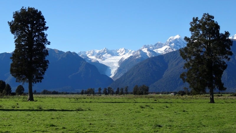
Continuing south took us to the town of Fox, where the equally majestic Fox Glacier resides. We parked up for the evening and went for a meal in the township, before getting an early night.
Day 3: Lake Matheson, Fox Glacier and Haast Pass
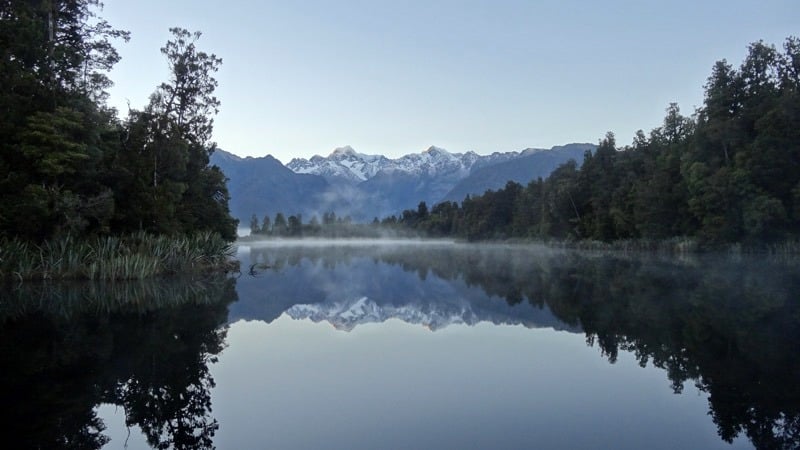
Ten minutes from Fox lies Lake Matheson, a pristine body of water originally formed by glaciation, nestled within a dense tangle of pine and ferns. An hour-long walk takes wanderers to the far side of the lake and offers a stunning view back inland to the Southern Alps mountain range. The lake is sheltered and silent, and when the weather is calm the still water rewards visitors with a breathtaking reflection of Mount Cook and Mount Tasman. We arrived at 6.30am to watch the sun rising across the snowy peaks, slowly painting the summits with a glowing pink hue. Joined by a handful of more serious photographers who’d set up tripods to catch the perfect reflection, Tom and I laughed at their annoyance when a rebellious duck decided to glide out on the serene water, rippling the reflected image and temporarily ruining their photos. The tranquillity and backdrop made it one of the highlights of the trip and definitely worth the early alarm!
With the sky turning into a wash of cornflower blue, we took the opportunity to nip across to the beach, again bordered by dense forestry, before heading back to Fox. The second glacier is more exposed by the mountains and we had some great views whilst driving back inland. Again, when we got there we chose the walk to the base and, although different to Franz Josef, Fox is no less impressive, perched proudly between soaring snowy summits. This region of the island really does boast remarkable topographical changes within a very small geographical area – in just one morning we walked beside lake, rainforest, beach and glacier.
Continuing our journey south we drove through sweeping hills and mountains, before cutting through the Haast Pass towards the centre of the South Island. We stopped off for a short walk to the Blue Pools, which are a gorgeous cluster of turquoise pools filled with meltwater from the surrounding mountains. In warmer months adrenaline junkies jump off the suspension bridge into the clear waters below, but a feel of the icy ripples lapping at the shore quickly put us off!
Our final drive of the day took us further inland, past rolling hills and glassy lakes, to the town of Wanaka. Here we parked up at a campsite, plugged in to the power, and then wandered into town to meet up with some Canadian friends for dinner.
Day 4: Roy’s Peak in Wanaka
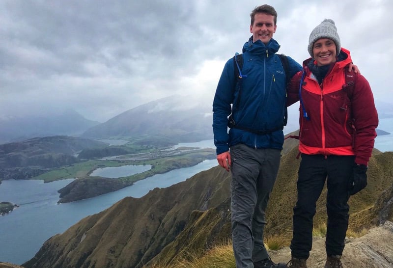
A visit to Wanaka is not complete without conquering Roy’s Peak. Over 1,500m tall, the mountain towers above the Lake Wanaka basin and provides panoramic views north to Mount Aspiring National Park. More used to completing kilometres in the pool than on land, I donned my walking gear and we set off on a determined march up the mountain. The walk is mainly steady, with some steep climbs, though there are plenty of places to stop and take in the views. At one point we accidentally left the path and started precariously traversing an exposed rock face whilst being buffeted by the wind. Two and a half hours (and three bags of M&Ms) later our aching legs reached the top, only to be denied a view from the highest point due to low cloud and rain. Nevertheless, the climb was awesome and the views along the way were spectacular. In total the hike took us around four hours – not for the fainthearted but 100% justified for the vantage point across Lake Wanaka and the surrounding snow-capped peaks. This is one of the occasions where being prepared for the elements paid off – it was roasting as we hiked lower down, but the icy wind picked up as we neared the top and we ended up needing full waterproofs and wishing we had thermal pants. On the way back down, we passed a guy hiking up in flip flops and a t-shirt – what a maniac!
By the time we’d made it back to base (knees just about intact), we were pretty hungry (and I was a little grumpy), so Tom cooked up a quick pasta dish in the motorhome to refuel our aching legs, and then we set off for Queenstown. By all accounts this is a great drive, but we did it in the dark so didn’t really get the full experience of the winding route, though navigating the hairpin corners kept us on our toes! That evening we stayed at the Creeksyde Holiday Park, an eco-friendly campsite just on the edge of town.
Day 5: Mountain biking in Queenstown
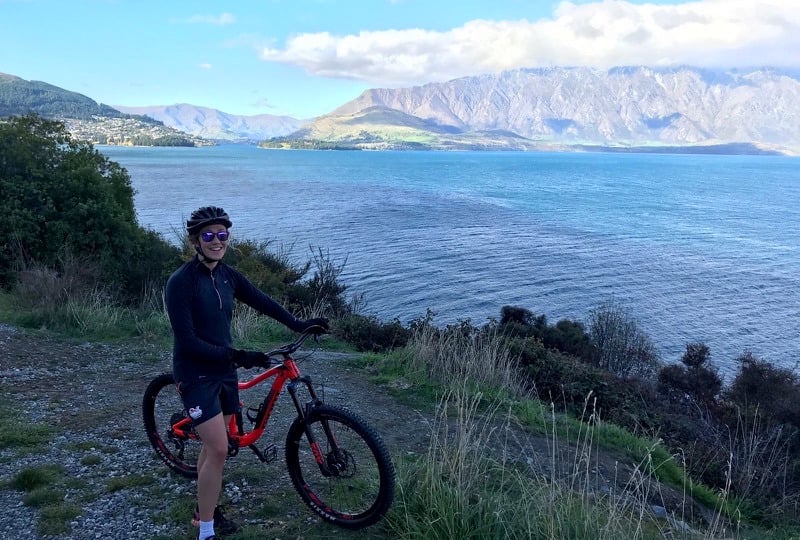
We’d done a pretty full day of driving the day before so opted for a lazy morning and then a wander into town. Queenstown is a buzzing hive of activity and offers numerous pursuits for thrill-seekers, from mountain biking to jet-boating, skydiving and bungy-jumping. After lunch in town we decided to hire bikes for the afternoon and cycle out to the Seven Mile Bike Park, a mountain biking mecca of purpose-built trails ranging from flowing gradients to terrifyingly technical descents. Tom’s a relatively experienced biker but my focus has been more aquatic based over the last ten years, so I was a little rusty. We picked some medium difficulty trails and, with Tom racing ahead, I’d just started to get the hang of being on two wheels again when my natural inclination to be uncompromisingly competitive somewhat backfired. Some challenging technical downhill terrain swiftly transitioned into a couple of rollers, which I swept into with too much speed and not enough skill. Panicking, I hit the brakes at the top of one of the jumps, and Tom turned around just in time to see me fly over my handlebars and hit the deck. Winded and bruised, we checked for permanent damage, but apart from one hand that was inflating at an alarming rate I appeared to be ok. The journey back to base, however, suddenly seemed like it would be a long one. Luckily a lovely Kiwi family weren’t far behind us and they directed us back to the trail car park before bundling us into their truck (bikes and all) and taking us back into town.
We had some food in the motorhome and I nursed my injuries and damaged pride, and then we set off for Te Anau, where we planned to stay for the night before hitting the legendary Milford Sound the next morning. As we were soon to learn, even the best laid plans often go awry…
Day 6: Milford Sound Attempt 1
We’d booked a boat trip for 11am, so set off from Te Anau at 8. Unfortunately, just half an hour into the journey a roadblock stopped us in our tracks. The route to Milford Sound climbs through the mountains and recent snowfall had resulted in dangerous conditions for travellers. We were told the next update would be later in the day, but that there was no way to make our trip that morning.
Somewhat disheartened we returned to Te Anau, where the weather had closed in, concealing the lake and nearby mountains in mist. By this time my left hand had swollen to double its normal size and I was having trouble moving a couple of fingers, so we cut our losses and hit the Fiordland Medical Centre for a professional opinion. Luckily there was no break (just some ligament damage), which was reassuring as I didn’t want to be too hindered for the rest of the trip!
We’d been told by everyone who’d visited New Zealand not to miss Milford Sound, so we accepted the wasted day, stayed in Te Anau again, and went out for an awesome dinner of Aoraki salmon and roasted venison. Setting an alarm for 6am, I fell asleep with my bruised fingers crossed, hoping for better weather the next morning.
Day 7: Milford Sound Attempt 2
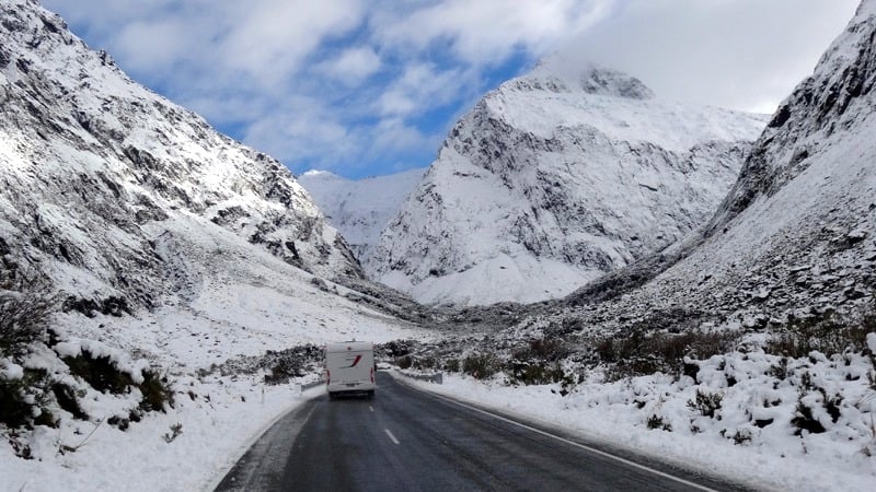
As the morning broke we could see the weather gods had finally been kind to us, and although the last online update said the road was still closed further along, we hedged our bets and set off. Big fluffy clouds floated amongst the hills but there was no sign of rain as we left Te Anau and headed for Fiordland. As we climbed higher the terrain transformed into a snowy wilderness; rugged peaks silhouetted against a cobalt sky. We were one of the first vehicles to reach the pass through the mountains, which was (as googled) still closed, but scheduled to reopen within an hour. We formed the beginning of what would be a long queue of traffic, set an alarm and settled in for some Netflix and a power nap!
As soon as the road reopened we cruised onwards through an unbelievably stunning alpine landscape. The rock here is dark and brooding and contrasted sharply with smatterings of snow to create a majestic monochromatic vista. Tom was driving which meant I was on photo duty – one arm hanging of the window trying to capture the view as we meandered down to Milford!
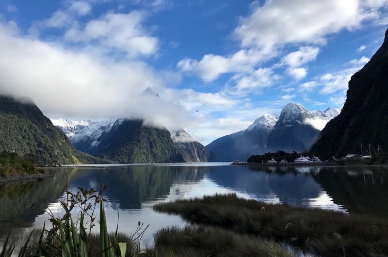
If I thought the journey was good, then things were about to go to a whole new level once we arrived. Magnetising people from across the world, Milford Sound is hard to do justice in words or photographs. Situated on the edge of Fiordland, the pristine waters are framed by sheer rock faces and high waterfalls that cascade hundreds of metres from the rainforests above. Squatting in the centre of the fiord is the iconic Mitre Peak, an imposing prominence, towering 1,683m above the waters below. Milford Sound is heaven for those seeking an adventure, with options to hike, climb, kayak, paraglide or take a plane ride to view the alluring setting. We’d chosen the most popular option – a scenic boat trip on one of the ferries that line a hidden harbour. For the next two hours my jaw barely left the deck as we cruised out of the fiord onto the waters of the Tasman Sea. Snow still capped the mountain summits, icing a lush blanket of foliage on the lower slopes, and clouds floated amongst the crags, leaving wispy contrails that gently buffeted the cliffs. We’d barely left the harbour when a pod of dolphins starting frolicking in the bow wave, playfully racing one another before disappearing into the depths. As we nosed closer to the sheer rock faces, we saw rainbows dancing in the spray of hundreds of waterfalls, arcing delicately through showers of meltwater from the peaks above. I was utterly mesmerised by the magic of the place, and quite expected to see a couple of unicorns prancing through the valleys!
With over 300 inches of rainfall each year, we were lucky to experience the fiord on a clear day though, by all accounts, it’s takes on an equally transfixing aura whilst under a blanket of fog and drizzle. There’s a reason that Rudyard Kipling regarded Milford Sound as the eighth wonder of the world. Not to be missed at any cost.
Day 8: Glenorchy and Queenstown
After a lazy morning back in Queenstown we took a drive to Glenorchy. Nestled on the Northern shores of Lake Wakatipu, Glenorchy and neighbouring village ‘Paradise’ are famed for set locations in The Lord of the Rings movies (specifically ‘Isengard’, for the true fans), as well as Narnia and The Hobbit. This shallow, bucolic valley offers breathtaking views to Mount Bonpland and Mount Alfred, and south across Lake Wakatipu. We went for a wander (quite possibly trespassing through some farmland), spent a geeky twenty minutes trying to figure out the angles of Isengard, and then headed back to Q’town.
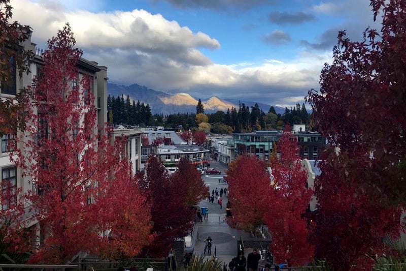
No visit to Queenstown is complete without a gondola ride, carrying visitors 450m above the township and offering panoramic views of Coronet Peak and the aptly named ‘Remarkables’ mountain range. It’s a great way to see the town, though be prepared for a swarm of tourists who all have the same idea. For those wanting a quieter view, you can do a steep climb to the top of Ben Lomond, and there’s also a renowned mountain bike park on the slopes. That evening we hooked up with the Canadians again for dinner, and then went to a bar where Graeme James (an awesome Kiwi multi-instrumentalist) took to the stage with his loop pedal, guitar and violin.
Day 9: Kawarau River Bungy and Lake Pukaki
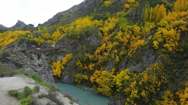
Following the road north-east out of Queenstown takes travellers along the Kawarau River valley. Being there during Autumn meant the leaves on the trees lining the steep slopes of the river were a gorgeous scramble of yellows and burnt orange, shouldering the icy blue water below. We pulled over to take a picture, only to notice that we’d stopped beside a suspension bridge linking the two riverbanks, almost 50m above the water. On closer inspection there was a huddle of people in the centre of the bridge and there seemed to be a lot of shrieking going on. Worried we might have disturbed some angry locals we quickly realised that we’d inadvertently found one of Queenstown’s most iconic bungy bridges, which is also the world’s first ever permanent bungy site. We laughed as a few crazy people launched themselves into thin air and then started wandering back to the motorhome.
Passing the bungy information hub on our way, Tom asked me, “You don’t want to have a go do you?”
I replied, “Definitely not, do you?”
“No”, he said, “but will we regret it if we don’t?”
“Hmmmm”, I pondered, “probably, yes”
“Ok… so should we do it?” he asked.
“I guess we should!”
Apparently we didn’t need much persuasion!
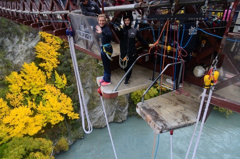
An hour later (there was a strangely large queue of thrill seekers ahead of us), we were trussed up, terrified, and ready to go. Shuffling towards the edge, the river below looked incomprehensibly far away, and my whole body went into innate survival mode, screaming at me to stay on solid ground. As I took the leap of faith my many years of swimming training kicked in and I executed a perfect streamline dive, feeling the pure euphoria of free falling before dunking my arms and head in the river (this was pre-planned!), and then bouncing back up towards the bridge.
The bungy experience isn’t cheap (and to be honest, the thought of a budget bungy is terrifying), but it was an incredible experience and we both left the Kawarau River invigorated and buzzing with adrenaline.
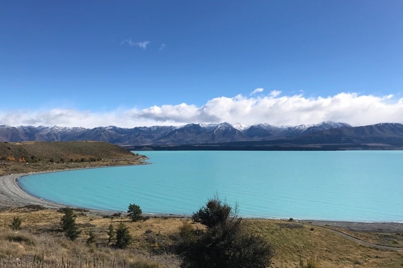
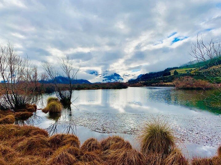
Continuing our journey took us to Lake Pukaki, a bright turquoise body of glacial meltwater, sitting in the shadow of Mount Cook and its rugged National Park. There aren’t many campsites around Lake Pukaki, but there are plenty of freedom camping spots (specified zones where self-contained vehicles are allowed to stay the night) on the south and eastern shores. Dusk was falling as we arrived, so we left the main road and nudged our way through the forest on the eastern side of the lake, parking up a stone’s throw away from the water, with no other vehicles in sight. Once settled we opened a bottle of wine, cooked dinner and watched some Lord of the Rings (of course!).
Unspoilt by light pollution, the night sky in this part of the world is clear and profoundly dark. We fell asleep gazing through the skylight towards the Milky Way galaxy, listening to the sounds of gently lapping waves and the occasional pine cone clunking onto the roof above us.
Day 10: Sunrise at Pukaki, Hooker Valley, Tekapo, Mt Sunday
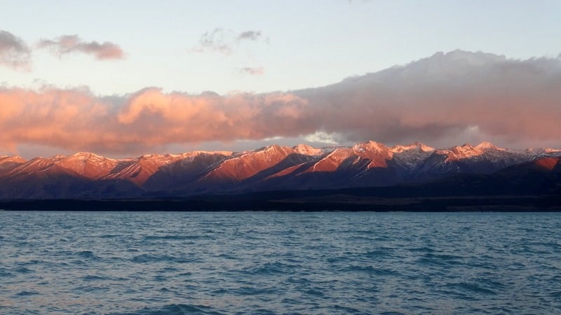
Tom and I woke early, just as the sky was starting to lighten, and took a walk along the waterfront. As the sun rose, the mountains on the opposite side of the lake were slowly bathed in pastel pinks, whilst the trees behind us became silhouettes in front of a fierce orange glow. Tiny shimmering ripples reflected the palette of colour on the lake’s surface and our breath misted in the chilly morning air. The water, fed by glaciers, was bitterly cold but I’ll always be a swimmer at heart, so I stripped off and took the plunge. Thirty seconds later I was out, shivering and numb, seriously regretting my impulsiveness. Still completely alone in our secluded campsite, Tom wrapped me in towels, and we sat drinking coffee and watching the new day arrive.
The drive to Mount Cook took about an hour and came with a brief panic when we nearly ran out of fuel - turns out we’d been so busy checking out the views that we’d not noticed how low we were! Luckily there was a petrol station in Mount Cook village, so we were spared the embarrassment of needing to be rescued. We’d heard a lot about Mount Cook and had seen it briefly from the other side of the Alps whilst travelling down the West Coast, but today we were planning on getting up close and personal. Unfortunately, the weather had other ideas and, although we’d left Pukaki bathed in sunlight, when we reached the base of the mountain it was entirely obscured by cloud and rain. We decided to check out the Hooker Valley Track anyway and spent an hour or so wandering along bridges suspended across the valley. The wind was so strong at one point that the bridges were undulating and swaying, giving the distinct feeling that one had had too many gin and tonics! In good weather this would be an awesome walk to do but it was a bit frustrating for us to know how tantalisingly close the mountain was but be unable to catch a glimpse!
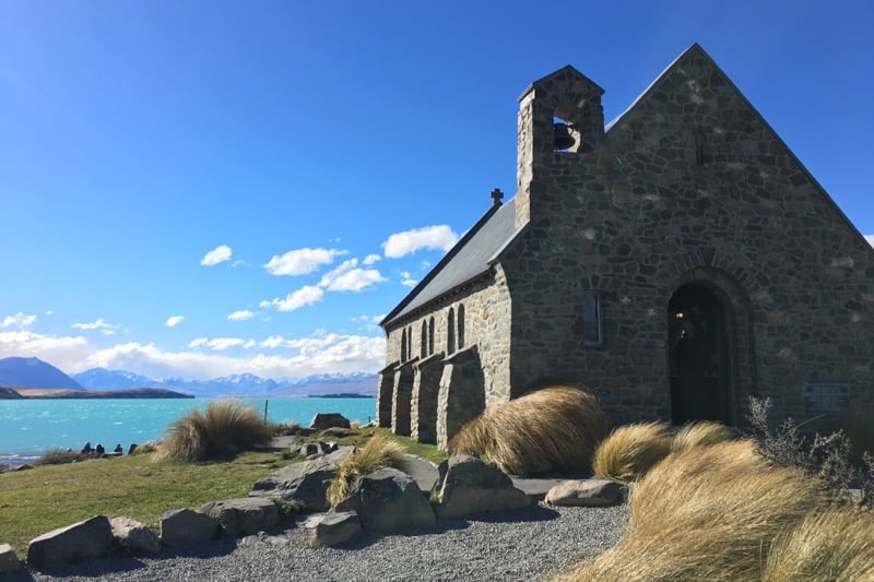
From Pukaki to Tekapo and another startlingly blue lake. We stopped at the Church of the Good Shepherd on the southern shore and had some lunch, before starting to head back east towards Christchurch. On the way we made a spontaneous detour to see Mount Sunday (another Lord of the Rings filming location), which is located about 30km off the main road, but took us an hour to reach because the road was so bumpy! Located on private land, there are no buses taking tourists towards it and we saw barely any other vehicles. When we arrived, the light was filtering through the valley onto Mt Sunday, the shouldering mountains cloaked in darkness. Tom went for a quick run to the top (it’s more of a mound than a mount!), I had a chat with Frodo, and then we continued our journey.
Arriving in Christchurch we linked up with some friends who had moved out from the UK a couple of years ago and were now staying on an alpaca farm and living the dream. We spent the evening catching up and hearing about their adventures in New Zealand, secretly sad that it was our last night on the South Island and that we’d have to return to reality soon!
Day 11: Christchurch
We spent our final morning having brunch and a wander in Christchurch, before packing up our motorhome, which had been so much fun to drive for the last ten days. One last trip to the petrol station for fuel and gas, and we made our way back to Wilderness, sad to be turning our backs on an incredible South Island adventure. New Zealand we will be back!
Learn more about planning a NZ motorhome itinerary.